
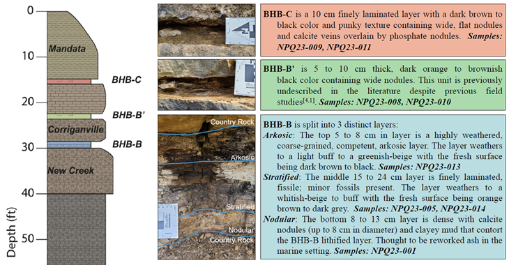
The New Paris Limestone Quarry was formerly a New Enterprise Stone and Lime Co. quarry for economic use of the Helderberg limestones. This quarry sits along the northwest limb of the Chestnut Ridge anticline in the eastern part of the Allegheny Plateau, on the boundary between the upper Silurian (~423 Ma) and the lower Devonian (~410 Ma). The Helderberg limestones are the result of shallow marine and tidal sea environment present in western Pennsylvania during this time. Within the limestone units at New Paris lie three volcanic ash layers named: Bald Hill Bentonite A (BHB A), Bald Hill Bentonite B (BHB B), and Bald Hill Bentonite C (BHB C), collectively, the Bald Hill Bentonites (BHBs). Bald Hill Bentonite A has been age dated at 417.6 Ma (Hanson, 1995) and Bald Hill Bentonite C has been age dated at 417 Ma (Gold et al., 2003). These volcanic ash layers originated from regional magmatism and volcanic activity on the east coast of North America which was particularly diverse during this period and it is unclear which volcanic style was dominant and responsible for their deposition (Sinha et al., 2012). Determining which volcanic style is responsible for the volcanic ash layers will allow for a greater understanding of the tectonic processes occurring during this active period of the Appalachians.
Igneous rocks, such as
volcanic ash layers, can contain unique geochemical signatures of
immobile
trace elements which, when plotted on geochemical discrimination
diagrams,
these geochemical signatures can reveal the magmatic source of the
igneous
material (Pearce et al., 1984). Recent studies have applied these
methods to
determine the magmatic origins of bentonite volcanic ash layers (Ge et
al.,
2018; Kiipli et al., 2008). Applying this practice to the New Paris
locality
will determine the magmatic source of these ash layers. In the future,
it will
be possible to repeat this process with other localities for further
correlational studies. Funding will allow geochemical analyses of the
BHBs to
ascertain what the magmatic source was, as well as chemically
“fingerprinting”
these bentonites. Understanding the source of these ash layers will
allow for a
better understanding of regional tectonics and its influence in the
creation of
the Appalachian Mountains.
- Howard, C., Shreckengost, A., and Kerrigan, R.J., 2023, The Geochemistry adn Petrology of the Bald Hill Bentonoites in Southwestern Pennsylvania. Geological Society of America, Abstracts with Programs, v. 55, n. 6, pp. 186-23.
- Howard, C., Kerrigan, R.J., Mathur, R., and Valencia, V. (2025) U/Pb Zircon Geochronology of the Bald Hill Bentonite Suite at the New Paris Quarry in Southwestern Pennsylvania. Joint Northeastern/North-Central Section Meeting of the Geological Society of America, Abstracts with Programs, v. 57, n. 3, pp. 5-47. Poster
I'm always looking for interested students to take on more projects!!!
Future Projects on Alleghany Plateau Geology:
- Pb-Zn mineralization in low-T hydrothermal regions
- Petrology and Geochemistry in Portugal
- Petrology, Geochemistry, and Structural Geology of Ultramafic Rocks
- Petrology, Geochemistry, and Structural Geology of Pegmatites
- Petrology, Geochemistry, and Structural Geology of Granites
- Structural Geology of Large Fracture Zones in the Allegheny Plateau
- Environmental Assessment and Remediation
Top images (left to right): Geologic Map of the Youngsford Road ultramfic body; field work at Bells Mill Road with Ryan Kerrigan, Loring Simboli, and Sam Louderback; XPL image of orthopyroxene altering to anthophyllite; Secondary electron image of relict olivine altering to serpentine; field contact between the Bells Mill granodiorite and the Wissahickon schist; trace element chemical discrimination diagram for serpentinites. Copyright © 2025 Ryan Kerrigan (last updated Jun 2025)